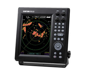
The marine radar is equipment that is perhaps used the most on the ship’s bridge by the OOW in carrying out a safe navigational watch. A mandatory aid to navigation, the radar is used in identifying, tracking (with integrated ARPA) and positioning of vessels (including one’s own vessel) among other things in order to adhere to the COLREGs so as to safely navigate a ship from one point to another. The marine radar is classified under the x-band (10 GHz) or S-band (3GHz) frequencies. The x-band, being of higher frequency is used for a sharper image and better resolution whereas the S-band is used especially when in rain or fog as well as for identification and tracking.

Tracking ship devices are compulsory as per COLREGS (International Regulations for Preventing Collisions at Sea). SOLAS Chapter 5, Regulation 19 states that “All ships of 3000 gross tonnages and upwards shall, in addition to meeting the requirements of paragraph 2.5, have a 3 GHz radar or where considered appropriate by the Administration a second 9 GHz radar, or other means to determine and display the range and bearing of other surface craft, obstructions, buoys, shorelines and navigational marks to assist in navigation and in collision avoidance, which are functionally independent of those referred to in paragraph.”

The entire SOLAS Chapter 5, Regulation 19 can be read here. Additionally, the Annex 16 dealing with specific information with regard to the marine radar onboard can be read here. With the help of ship radar, accidents can be prevented at sea with the use of the various inherent functionalities of the radar (determining the CPA and the TCPA, EBL, VRM etc). However, even while the ships are docked in the port, with the help of these radars, the coast guard, VTS and the other authorities can use them to monitor the traffic in the small radar range.

Features

• Superior ability to display closed range targets.
• Able to interface with AIS and target display.
• Able to Zoom-In the special target area for use’s selection.
• Able to choose brightness of color in 10 levels for navigation at night.
• Can choose the screen color within white, yellow, green.
• Adopted 8 directions key to make cursor move with speed.
• Can set up the range in many ways the user needed.
• Intermittent Tx mode : can operate with low electric consumption.
• Can move screen center point and observe the long distance of the desired direction.
• Display parallel line : Can maintain certain distance between other vessel.
• Setting-up warning zone for invasion and separation in various method

Specifications

▶ ANTENNA
• Type : dome-type antenna
• Output power : 4KW
• Tx frequency : 9410±30MHz
• Revolution : approx. 24rpm
• Beam width : Horizontal 4.0° / Vertical 25°
• Synchronism method : Automatic / Manual switch over
• Operation temperature : -25℃~+55℃
• Relative humidity : 35% ~ 95%
• Relative wind velocity : 51.5 m/sec(100 Knots)

▶ DISPLAY UNIT
• Display unit : 10.4Color VGA TFT LCD, Vertical display
• Resolution : 640×480
• Indication type : scan type
• Distance range : 0.0625, 0.125, 0.25, 0.5, 0.75, 1, 1.5, 2, 3, 6, 12, 24, 36nm
• Minimum distance : within 25m
• Azimuth accuracy : within ± 1°
• Azimuth resolving power : 4.2°
• VRM : .000 ~ 64 NM display in digital
• EBL : 000°~ 359° display in digital
• Indication of bow : electronic type
• Display mode : head-up, north-up, course-up
• Operation temperature : -15℃ ~ +55℃
• Pre-heat time : approx. 90 sec.
• Input data : NMEA 0183(2port), AIS(RS-422)
• Consumption power : 60W
• Power supply : DC +10V ~ +36V

There are no reviews yet.

Be the first to review “Radar Samyung 36 nm SMR 3700”